Administrative Divisions
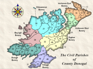
Civil Parishes: The Civil Parish was the original unit of administration of the medieval church in Ireland and was used right up to the end of the nineteenth century for local and central government. Because of this, Civil Parishes are extremely important for Irish genealogy, providing, in many cases, the only means of connecting a placename to the Roman Catholic records which cover it. Each of the civil parishes of Donegal has a page here which can be accessed via any of the clickable maps, or by the list of parishes here.
Townland: Since at least the medieval period, every county and parish has been divided into small land units known generally as townlands . These units were formerly called by a variety of local and regional names, such as “balliboes” in parts of Ulster, “tates” in Fermanagh and Monaghan, and “ploughlands” in some southern counties. Despite frequent enlargement and division, the basic townland pattern has survived to the present day.
Townlands vary in size from a few acres to several thousand, averaging 1.3km2, large enough to contain a number of farms whose owners were kin and traditionally co-operated in various ways. Townland boundaries are often marked by streams or deep ditches, banks and old hedges. Townlands are characteristically larger and elongated in elevated areas but dense on the lowlands, and their orientation tends to reflect the local variations in land contour. Numbering more than 65,000 in the 1851 Townlands Index for all Ireland, townlands no longer have significance as units of social and agrarian life, but in a country of dispersed rural settlement where farms lack individual names, the ancient units still have use for conveying topographical information and for postal addresses. The townland was and is the smallest officially recognised geographical unit in rural Ireland. Baronies: Up to the end of the nineteenth century, counties were subdivided into baronies. These were not much used for administrative purposes and thus figure little in the records relevant to genealogical research. There were about 325 baronies in the whole of Ireland, with eight covering County Donegal. A map of the Baronies of Donegal can be found here.
When a civil parish spans more than one Barony, the parish page will indicate to which a townland belongs. Occasionally a townland spans two Baronies; in such a case, there will be two entries for that townland in the townland list. Poor Law Unions: These were the catchment areas of the workhouses set up from the 1830s on to try to deal with the most destitute. They became the basis of the registration districts later used to record births, marriages and deaths. The PLUs of onegal bear only a rough relation to the county’s civil parishes, so it has been necessary to indicate PLU on the various parish pages, and frequently to specify the PLU for individual townlands A map of the Poor Law Unions can be found here.
| 1. Aghanunshin | 14. Desertegny | 27. Killybegs Upper | 40. Moville Lower |
Ecclesiastical Parishes – These come from Fianna Guide to Irish Genealogy.
Townland Names – I’ve used a number of lists, none of which is exactly the same in every detail. Lindel Buckley’s web pages have been very useful in this regard, as has Sean Ruad’s IreAtlas Townland Database, both extremely valuable resources.
Townland Areas – From the IreAtlas Townland Database. If this column is blank, it means that one or more of the townland lists has an entry that’s not in Sean Ruad’s database. The database will usually be correct, and that the lists, or the choices from a selection of lists, are more likely to be wrong.
Note: Listed acreages are based on the current value of the acre, which is 4047 m2 or 4840 yd2 . Although the measures are now obsolete, older documents may use either the Scottish Acre which was 27% larger than the modern acre (6150 yd 2 or 1.27a), or the Irish Acre which was 62% larger than the modern acre (7840 yd2 or 1.62a). It is interesting to note that another obsolete measure was the Barony, which equalled 4000 acres (English, I presume).
From-Ireland – Jane Lyon’s Irish genealogy website has made a great deal of information available online to County Donegal researchers, and for this we owe her a debt of gratitude. With her permission, I have made a number of links from this site to hers, in particular to the extracts from Lewis’s Topographical Directory of Ireland, 1837.
[Note: this page of information was compiled by Bob Hilchey – it used to be available on Rootsweb as a free page. I happened to save the page many years ago for the information and that’s why I am able to put it here. The old links still seem to work.]